


Explore The Heart of Japan: HIKES and WALKS
MYOKO CITY, MYOKO-KOGEN, IIYAMA, TANGRAM, MADARAO, LAKE NOJIRI AND TOGAKUSHI
MOUNTAIN HIKES and WALKS IN and Around MYOKO KOGEN
HIKING AND MOUNTAIN CLIMBING
The local Shinetsu-kogen region is famous for the Shinetsu ‘Five Mountains’ Trail which is approximately 100 kilometres in length. A race takes place each September and the 2009 dates are 22 and 23 September.
A good local Japanese trekking/hiking/walking guide for the Myoko area is here.
SHIN ETSU TRAIL – OPENED SUMMER 2009
This newly completed hiking trail runs for eighty kilometres through the Sekida mountains starting near Lake Nojiri. The trail runs through a relatively easy accessible range of thosand metre peaks covered with old forests of Japanese buna beech trees. These woods, filled with springs, lakes and ponds, are unique for being almost entirely free from other tree species, and also for the way they have been shaped and polished by the region’s heavy winter snowfall. The Shinetsu Trail is open year-round, and is a wonderfully convenient way to explore the delights of nature in Japan. You can download maps and info here(Japanese), see a Shin Etsu Trail video (English) here plus see a photo album here from the Shinetsu Trail Club (Japanese).
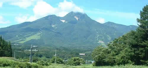
MOUNT MYOKO
There are two renowned hiking areas in Myoko Kogen – Mount Myoko and Mount Hiuchi, both of which are home to stunning flowers which appear in spring, when the snow starts to melt. A guide to summer flowers is here. At the other end of summer, Autumn brings a beautiful array of bright colours set against the clear blue skies (see video below).
Most climbers first attempt Mount Myoko which is 2,454 metres high. From times of long ago it has been claimed that on a clear day one could see the famous Mount Fuji and also Sado Island from the top of Mount Myoko which is a former active volcano.
Here is one hikers climb of Mt. Myoko
You can however start this climb the easy way in summer by taking the gondolafrom Akakan Ski Resort (cost Y1,500) or the bus to Sasagamine Pasture, but there are plenty of different routes to take, such as from Tsubame Onsen. Read another hiker’s experience here.
Recommended route: Sasagamine – Kurosawa Alpine marsh – Mt. Myoko – Tsubame Onsen. Time: approx. eight – nine hours

MOUNT HIUCHI
Mount Hiuchi at 2,462 metres is probably the toughest climb of all the Myoko peaks so be prepared. There is another blog about hiking from Mount Hiuchi to Myoko here.
Recommended route: Sasagamine – Koya Ike (pond) – Mt. Hiuchi – Koya Ike – Kurosawa Alpine marsh – Sasagamine. Time: approx. nine hours
SASAGAMINE PLATEAU (SASAGAMINE-KOGEN)
Hiking across the open Sasagamine Plateau, 1,300 meters above sea level, on the southwestern base of Mt. Myoko is a popular hike. The plateau is famous for the föhn winds that often result in warm, sunny weather even when it’s cloudy or rainy on the Akakura side.
Recommended route: Sasagamine Ranch – Norway Spruce forest – Shimizu ga Ike pond – Lake Otomi – Kyukamura Myoko. Total distance: 5 kilometers (3 miles).Time: approx. two hours
MT. MYOKO Base Trek
The Mt. Myoko Base Trek hiking trail leaves Akakura Onsen, passes by Shin-Akakura Onsen and Imori Pond, finally arriving at the scenic Naena Falls. This hike covers quite a distance, but aside from one slope between Shin-Akakura and Ikenotaira, the trail is fairly level. This route is recommended for hikers of all experience levels.
Route: Akakura Onsen – Shin-Akakura Onsen – Imori Ike – Suginosawa – Naena Falls. Total distance: 7.5 km Time: approx. three – four hours
MOUNT TOGAKUSHI
The rugged ridges of Mt. Togakushi attract many mountaineers, hikers and climbers. This mountain is sometimes linked to then religious myths associated with the foundation of early Japan. Also regarded as a sacred place, it has long been worshipped by Buddhists, making it the aim of many religious pilgrimages. Check out Togakushi hiking maps via the Togakushi English Travel Guide. Also, watch out for the wildlife!
MOUNT TOGAKUSHI Hike Review
A superb year-round destination for hikers as well as skiers, and the ascent of Togakushiyama is a great introduction to the area…
Hiking in Nagano: Togakushiyama-Door Hiding Mountain
Hikes In And Around MADARAO & IIYAMA
From the Hokuryuko ski area near Iiyama there are several hiking trails that link up to eventually lead to the inner shrine of the Kosuge Shrine. It’s a fairly steep slog up hill for forty minutes but the shrine is very pretty and the views back to the plain are great. There is also a delicious freshwater mountain spring next to the shrine to fill your water bottle up at!
The Madarao Plateau trekking route, which was selected as one of the “Best 100 walking routes” by the Yomiuri Newspaper, extends for around fifty kilometres in total at an altitude of around 1,000 metres. Other various courses are available to suit all needs, such as the Madarao nature trek as well as wetland and beech forest courses
YUDANAKA ONSEN and SHIGA KOGEN HIKES
You will find information on many hiking trails in and around Yudanaka Onsen and Shiga Kogen here. Places include Shibu-ike (pond), Hyotan-ike, Mt Urashiga (2040m), Shijyuhati Marshlands, Mt Hatchiyama, Mt Shiranesan (2160m) Lake Yugama, Mt. Ainomine, Lake Yumike and Onuma-ike.
Other Hikes
Some other recommended mountains could include – Mount Obatsu (Before the modern period local villagers, in order to save limited resources, had a tradition of taking their elderly to the top of this mountain and abandoning them there),Mount Akakura (2,141 metres) and Mount Kurohime (2,053 metres). Please stick to the prescribed tracks and take note that Mount Yake is closed (as of August 2003) due to suspected thermal activity. There are mountain huts in the Myoko area that can be utilised for breaks and/or overnight stays.
Some other hikes around the area are described here…
Walking
Less strenuous walks could be along and around the shore of Lake Nojiri. Maps (in Japanese) for walks in the Lake Nojiri area are available here. See a Lake Nojiri webcam here
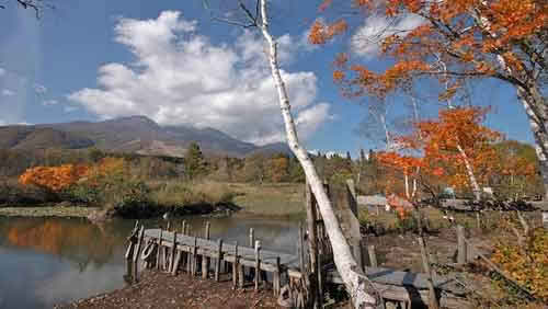
At Imori-ike (pond) in Ikenotaira (below) you can enjoy a relaxing walk along the path that circles the pond (see the Imori-ike webcam below). The adjacent Ikenotaira Vistors Centre is also quite interesting.
In both places you can enjoy a nice meal, snack or coffee afterwards.
Mt. Takatoko 高床山 is a 35 sq.km parklands with wild birds and attractive flora and fauna. It’s a vast land with campsites, cottages, tennis courts and other sporting facilities. You can enjoy yourself in various ways in this park, which is open from the end of April to mid of November.
Kyozukayama Park 経塚山 in Arai has a breathtaking beauty, not only when 400 cherry trees are in a full bloom, but from spring to autumn the park offers a variety of colours and great recreational area. The view of the Arai area from the park is magnificent.
HERE’S SOME OF THE BREATHTAKING AUTUMN SCENERY YOU CAN DISCOVER.