


Nagano Maps, Myoko Maps, Hakuba Maps, Nozawa Maps
New Nagano Maps: Hakuba and Nozawa Onsen
Check out our comprehensive map guides for Hakuba and Nozawa Onsen. Both pages feature village and ski trail maps in downloadable and printable formats.
Myoko-Nagano Area Map
An large interactive map of Shin’etsu-kogen region from Togakushi and Izuna to Lake Nojiri, Myoko-Kogen and up to Madarao-Kogen and Iiyama. This map links to local ski resorts, hotels, golf courses and local travel guides. (Size – 672kb)
Myoko Ski Resort Resort Map
An interactive ski map of Myoko-kogen and the main adjoining resorts – Myoko Suginohara, Ikenotaira Onsen, Akakura Kanko, Akakura Onsen, Seki Onsen, Tsubame Onsen, Kyukamura and Myoko Ski Park (size – 240kb)
Myoko Kogen Area Guide Map
This little gem is courtesy of the Myoko City Tourist Office. Can be printed out on two A4 pages and kept for handy reference. It covers mostly eateries, shops, etc., in the Myoko Kogen area as well as a Myoko ski resort lift guide. Download the Myoko Kogen area guide map here.
Google Maps
Another handy tool is our newly constructed and comprehensive Google Nagano maps
Joetsu City, Takada, Naoetsu and Arai
Seki Onsen, Tsubame Onsen and Myoko Sekiyama
Akakura Onsen and Shin Akakura (joint map)
Akakura Onsen and Akakura Village
Shin-Akakura (a.k.a. Akakan Resort or Akakura Kanko Resort)
Myoko Kogen (central area around the station)
Ikenotaira Onsen
Madarao Kogen
Nozawa Onsen
Myoko Suginohara and Suginosawa Village
Lake Nojiri, Shinano-machi and Kurohime
Togakushi Village and Iizuna-machi
Yudanaka Onsen, Shibu Onsen and Kambayashi Onsen (Snow monkey hotsprings)
Hakuba Village
Nagano Maps – Nagano City and Zenkoji Temple
Nagano Access Guide
Getting to Myoko-Kogen, Togakushi, Iiyama and Lake Nojiri
A series of access maps can be found here. These include rail stations, airports and road maps.
Lake Nojiri Access Map
A smallish map showing the different routes to Lake Nojiri
Madarao and Iiyama Access Map
Can be downloaded right here.
Myoko Town Area Maps
Myoko Kogen Tourist Pamphlet
A tourist pamphlet showing the main features of the region, as well as introductions to the main ski areas. Not as comprehensive as the Myoko Kogen area guide map above.
Download the Myoko Kogen Guide Map in PDF format
Myoko Map
This map gives a overview of the wider Myoko-Kogen (Myokokogen-machi) area and some of the nearby ski resorts. Note – the map says ‘Myoko Kogen Village’ but this is a misnomer. Myoko Village (Myoko-mura) is actually the area around Sekiyama Station and extending up towards Seki O nsen (at the right of map). The map also covers parts of Shinano-machi and Lake Nojiri in neighboring Nagano Prefecture.
Shin-Akakura Map
This map gives a rough overview of the Shin-Akakura area (a.k.a. Akakura Kanko or Akakan) and the adjoining Akakan ski resort. You will see a number of nearby hotels.
Akakura Village Map
This map provides a good guide to Akakura Onsen Village, the nearby ski resorts, local hotels and things to do.
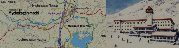
Myoko Kogen Area Map
A general map of Myoko Kogen, Kurohime and Lake Nojiri
Shin’etsu-Kogen Map
Another map of the area – this one stretching from Nagano City to the Japan Sea
Myoko Kogen Ski Trail Maps and Piste Guides
Ski Trail Maps and Piste Guides
This is a new page that will provide all Myoko Kogen Ski Trail Maps for you in a downloadable and/or printable form – both Japanese and English.
Myoko Kogen Ski Resort Map
The same as the interactive guide above but in .pdf format. Download a Myoko Kogen Ski Resort Map here.
Ski lift and course guides
Go to our a href=”http://myokokogen.net/”>ski pages and look for the maps on each of the individual resort pages.
Nagano Maps
Nozawa Onsen Map
See the Nozawa Onsen Guide for all your ski trail and village maps in Nozawa Onsen
Hakuba Village Map
See the Hakuba Maps Guide for loads more maps and information on Hakuba.
Togakushi Area Map
A general map of Togakushi, Iizuna-Kogen and Kurohime. Can be attached to the Myoko Kogen, Kurohime and Lake Nojiri map above for continuity.
Togakushi Shrine Walking Map
Going to Togakushi Shrine? This is a useful Togakure map showing the three shrines.
Check our Togakushi Guide guide for more info.
Walking Maps for Lake Nojiri
Three walking courses in Lake Nojiri (Nojiriko) and Kurohime-Kogen (Japanese only). Click on the ‘Map’ icons.
More maps as we discover them!